I feel that I must voice my opinion on the recently unveiled Phase II proposals for the DSH Pearl of the Caribbean development. I am a Saint Lucian marine biologist by training and fisheries and marine management specialist by expertise. I can bring to the debate over 30 years’ experience working in the interest of national development as a member of the Fisheries Department and also with the OPAAL project through which the Government of Saint Lucia established the Pointe Sable Environmental Protection Area (PSEPA) under the Physical Planning and Development Act.
This valuable site extends from Moule-a-Chique in the south to Pointe de Caille (just north of Savannes Bay) and includes Maria Islands and the Savannes Bay and Mankoté Mangroves as legally-declared marine reserves (with the area being designated as a RAMSAR site of international importance).
Given the valuable resources and ecological roles of the PSEPA and the way these support both existing and potential economic sectors and livelihoods, it is important that all Saint Lucians appreciate what will be some of the likely short- and long-term effects of building a causeway from the shoreline out to Maria Islands.
Smothering of critical marine habitats and endangering livelihoods
First, let’s consider the effects of a causeway on marine resources and essential ecosystem services along our southeast coast. Here we have Saint Lucia’s largest remaining area supporting three critical tropical marine habitats: mangroves, seagrass beds and coral reefs, all functioning together in an inter-dependent way.
These three habitats are valued worldwide as the basis for productive tropical marine food webs and coastal fisheries. They are also the source of the area’s clear and calm coastal waters which allow the reef and seagrass to thrive and give us valuable space for local and tourist recreation. The PSEPA sustains some of our most important nursery and breeding grounds for marine fish species, conch, sea urchins, lobster, crabs, and is also a key site for sea moss cultivation.
Creating a causeway in this area will end up burying large areas of the reef and seagrass habitats, resulting in loss of vital nursery, breeding and coastal fisheries grounds. As happened when Pigeon Island Causeway was built, the reclamation work involved in creating a causeway ends up smothering any reef or seagrass habitat within the boundaries of the causeway and in adjacent areas. It also causes long-term sedimentation and reduced water clarity over a large area in and around the works because fine silt particles generated by the reclamation process remain suspended and carried around by waves and currents for many years. Any settled silt is also easily re-suspended by annual storms and is added to by erosion that will naturally occur on and around the causeway as the sea battles against this artificial barrier placed in its way.
Beach loss and erosion along the coast
Another serious effect of placing a causeway between an area of mainland and offshore islands is the disruption it causes to the natural process of littoral drift (or “longshore drift”) which normally pushes sand gradually over great distances along the shoreline. This is how beaches are created and maintained by nature.
A beach forms in a location where the particular shape and topography of the shoreline, the direction and nature of the prevailing wave action, and size and weight of sand particles available to the area all suit the formation of a particular size and type of beach in that specific site. Longshore drift is driven by the prevailing wave direction, which feeds a continual supply of sand as beach material moves from place to place as part of this natural process. These large-scale nearshore dynamics determine which parts of our shoreline get eroded and which become built up with sand deposits.
A causeway not only blocks the littoral drift, and thus starves all the beaches downward of it, but also causes oncoming waves to be deflected around the structure and this ends up increasing the levels of erosion in some places along the nearby coast while causing others to become silted up over time.
Saint Lucia’s experience with the Pigeon Island Causeway and the Choiseul Fisheries Project has shown us first-hand the massive and costly problems caused when such artificial barriers interfere with natural nearshore dynamics. Significant loss of beachfront occurred for many years at Pigeon Island, in front of Gros Islet, and in the southern part of Rodney Bay. None of these areas have regained their former beach volumes despite efforts to put in place costly structures along the shoreline (seawalls, groynes, gabion baskets) aimed at preventing further erosion and protecting vulnerable coastal structures against storm damage. Even replenishing beaches artificially has proven costly and short-lived as the sea constantly reclaims the added material to regain the natural balance of the area.
The loss of beachfront caused significant loss of recreational space and caused collapse of what was a vibrant seine fishery in the Gros Islet area. The loss of healthy reef and seagrass habitat in Rodney Bay also led to a decline in other forms of fishing due to an overall loss of fish habitat. In the case of Choiseul, changes caused in the nearshore wave direction and longshore sand movement by construction of the fishing port have led to continual trapping of silt and creation of stagnant waters within the port. The walls of the “pond” inside the port prevent sand from moving along the shore or moving back out to sea. Money has to be spent to dredge the port, with no effective long-term solution found. Fishers remain frustrated and without a properly functioning port.
As part of the EIA (environment impact assessment) process or during the project development stage of developments such as these, hydrological studies are usually done in the proposed site, funded by the investors. These try to assess the nearshore dynamics of the area and factor this information into the way the reclamation and the proposed facility are designed. However, because coastal dynamics naturally fluctuate both seasonally and from year to year, and doing extensive studies is both costly and time consuming, such studies usually only provide a snap-shot of what is really going on. More often than not, they fail to accurately anticipate or prevent serious coastal impacts and long-term issues caused by the reclamation and the physical structures once in place.
Creating a coastal marine desert
The recently-released concept for Phase II of the DSH development shows a large marine space becoming “semi-enclosed” by the causeway – essentially establishing a large artificial bay. On the surface, this may seem like a benefit (i.e., new calm and physically protected coastal space for use in recreation or as a sheltered harbour). However, the causeway construction will tend to cause reduced water quality in the enclosed area, creating a “semi-stagnant” coastal marine space.
Presently, a wide range of species, including seagrasses and seamoss, coral reef fishes, lobsters and various hard corals, are able to set up and thrive in the well-oxygenated, clear waters of the southeast coast. If part of the bay becomes enclosed by the causeway, resources in the area become stressed by poorer water quality, high silt loads, and reduced flushing. Inevitably, natural runoff from land will add silt and other chemicals to this space and the causeway would act as a barrier reducing the rate at which they can be removed by wave action or wider coastal circulation.
These enclosed waters will also become less safe for sea bathing and water-sports. We saw these sorts of problems in Rodney Bay after the causeway was built: declining water quality, higher sediment load within the bay and die-off of seagrass, corals, fish and invertebrate populations. This led to a loss of coastal fishpot and seine fisheries and loss of livelihood potential for local, small-scale businesses which could have developed to provide visitors with opportunities for high-quality snorkelling, diving and glass-bottom boating within the wider bay. As is too often the case, a focus on the needs of large-scale developments get priority over local, smaller-scale but more sustainable enterprises that could keep a significant part of the tourism product and earnings in the hands and under the control of Saint Lucians.
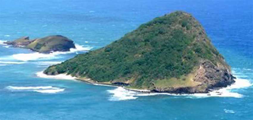
Threat to the Maria Island endemics
Finally, let’s look at one of the site’s smallest natural assets, yet one highly at risk in light of the proposed causeway: our extremely rare endemic species, the Saint Lucia whiptail lizard (Cnemidophorusvanzoi) and the Saint Lucia worm snake (Leptotyphlopsbreuli), with populations found nowhere else in the world except on Maria Islands.
These endemics exist on the two tiny islets because of the unique natural environment and the physical isolation the site has provided over hundreds of thousands of years. These factors have allowed the endemic species to evolve, adapt and survive there – and only there. The fact that an adequate stretch of sea separates the islets from the main coast of Saint Lucia has managed to prevent other animals and disease agents from getting to these rare endemics and destroying their eggs, young and adults.
Other rare endemic species around the world have been created by such physical isolation. A causeway would remove this essential element of isolation. Despite the best efforts of the Forestry Department and the National Trust to prevent other species becoming a threat, our rare Maria Islands endemics would be at severe risk of predation, disease and eventual extinction in the wild. As a result, we would fail to safeguard some of the world’s rarest species and also fail in our commitments to international agreements such as the Convention on Biological Diversity, among others.
Are causeways always a bad thing?
Causeways have been built in many places for many reasons and with varying effects on the natural environment. When a causeway or similar land reclamation project is built in an area where the marine system is a naturally dynamic, high-silt environment such as at the mouth of a large river system (like the Mississippi) or in an exposed, rough shoreline, they may not have a significant effect on existing species or habitats since the particular species present will already be those best suited to such turbid and dynamic environments.
In other cases, causeways have been built suspended above the sea, such as the road built to connect Prince Edward Island to mainland Canada. This raised structure is designed to reduce the level of physical disturbance to the seabed and disruption of wave action and littoral drift. But we must recognise that our southeast coast is not a high-silt, unstable environment, nor is the proposed causeway merely to be the base for a suspended road or one that will minimise impacts on natural coastal processes or our coastal marine habitats. Our sensitive nearshore environment around Saint Lucia is not a suitable place for a causeway.
Moving Forward
I very much recognise the urgent need for us to develop job opportunities, sustainable livelihoods and better services for communities of the south and that the outstanding natural beauty, coastal marine assets and available land in the south means that that tourism is going to be a major element in such development. But as a country we must be able to strike a healthy balance that can provide viable, sustainable social and economic progress for all Saint Lucians while safeguarding our environmental assets. Unlike larger countries such as the USA, Canada or China, Saint Lucia’s tiny size means that we have no room for environmental error; no room for easily moving from an environmental mistake to take up a “Plan B”.
The way forward in the case of the DSH project must be some form of compromise and such compromise must be rooted in the long-term interest of Saint Lucia over and above any short-term interests driven by political debate or external interests. While the proposed project seems at first glance to be full of the promises of jobs for everyone, we must consider the damage it can do to our resource base and consider hidden costs that can arise as we compromise existing livelihoods and the quality of our environment. We must take the time and care to consider other options, ones that would result in safer, sounder development for the south.
Whether you consider yourself UWP, SLP or no “P” at all, if you truly care about the future of Saint Lucia, I hope you can agree that the compromise we reach for development in the south must not include a causeway.
The No Causeway to Maria Islands Petition can be found at:
http://www.thepetitionsite.com/100/724/416/say-no-to-building-a-causeway-to-maria-islands-nature-reserve/?taf_id=34614417&cid=fb_na
Further Reading
The following documents, which you can access via the internet, may help you get a greater understanding of the issues discussed here. I have found that information, in-depth consultation, and then careful consideration brings wisdom, and wisdom provides the foundation for meaningful, equitable progress.
A case study of effects of the Pigeon Island Causeway: http://www.irf.org/eiacasestudy_failure_rodneybay_stlucia_op-45a/ (Ed Towle, 1985).
Saint Lucia National Trust information page on the Point Sable Environmental Protection Area:
http://slunatrust.org/sites/pointe-sables-environmental-protection-area/
A report on the values and perceptions of the Pointe Sable Environmental Protection Area:
https://www.google.co.uk/?gws_rd=ssl#q=Socio-economic+monitoring+by+Caribbean+Challenge+MPA+Managers+Report+No+…+Area+by+the+Saint+Lucia+National+Trust+…+Pointe+Sable+Environmental+Protection+Area+…+&* (Bethia Daniel, 2013)
BIO
Sarah George worked with the Department of Fisheries in Saint Lucia from 1982 and 2012. She was first a Fisheries Assistant, then a Fisheries Biologist, and ultimately served as Deputy Chief Fisheries Officer and finally as Chief Fisheries Officer at the Department. From 2005 to 2009, she was assigned to the Environmental and Sustainable Development Unit of the Organisation of Eastern Caribbean States (OECS) where she worked with the OECS Protected Areas and Associated Livelihoods Project (OPAAL). Ms George also served on a Marine Protected Areas Expert Working Group for the Convention on Biological Diversity, the Board of the Soufriere Marine Management Area, and has participated in a number of other local, regional and international fisheries development and marine management initiatives.
Once again I’ll mention the possibilities of development that is in harmony with protected areas – for instance, the UNESCO Man & Biosphere programme – there are so many ways in which we could get good jobs with sound footing for the future without destroying the landscape and fragile ecological assets in the way DSH will do
I hope that people read these articles and start seeking other ways and decide to stand against DSH as it is – we do need a better alternative than this and we must take pause and respect the growing number of Saint Lucians (including Vieux Fortians) who are against this!
hi