The OECS has been hailed as a model in Marine Spatial Planning among Small Island Developing States.
The Organisation of Eastern Caribbean States (OECS) came in for high praise and commendation during a virtual seminar on Sharing of Experiences in Marine Spatial Planning (MSP) to mark World Oceans Day on June 8. The marine spatial planning experiences of Barbados, Trinidad and Tobago, Seychelles and the OECS, were shared during the virtual forum.
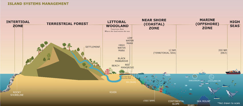
The OECS is the most advanced in MSP in the Caribbean region. Under the Caribbean Regional Oceanscape Project (CROP), Marine Spatial Plans have been developed for Dominica, Grenada, Saint Lucia, St. Kitts and Nevis, and Saint Vincent and the Grenadines. A Regional Marine Spatial Planning Framework is also being developed to facilitate cooperation in transboundary issues among OECS Member States.
Commending the strides made by OECS Member States under the CROP project, Director of Coastal Zone Management in Barbados, Dr. Leo Brewster, remarked:
“What you guys have done is phenomenal, in the sense that you’ve been able to light a path for others to follow. Barbados will try to use some of the same principles that have been pursued through the CROP to assist us in the way forward. We will be looking at the structured approach that the OECS has used under CROP as a guide, to help us move forward with our MSP process. We are now looking at the ‘Big Blue’ in a totally different light.”
Dr. Brewster indicated that in mid-2020, Barbados initiated its Marine Spatial Planning (MSP) process under the purview of the Ministry of Maritime Affairs with the Coastal Zone Management Unit as the lead agency. Barbados’ total land area is 432 square kilometers, while its Exclusive Economic Zone is approximately 400 times larger than its landmass. 70,000 square kilometers is set aside for offshore oil and gas exploration. The island has an Integrated Coastal Zone Management Plan, which guides coastal planning from a land-based perspective.
Speaking on Trinidad and Tobago’s marine spatial planning experience, Sarah Mahadeo, one of the Consultants who led a UNESCO initiative for MSP and the Blue Economy said that at present, the twin-island republic does not have an MSP process. However, in 2017, they benefited from a Joint Roadmap to accelerate MSP processes worldwide. That project was undertaken by the European Commission under its MSPglobal initiative, in collaboration with UNESCO.
The main aims of the MSPglobal project in Trinidad and Tobago were to raise awareness about Marine Spatial Planning and to determine among key stakeholder groups the opportunities and challenges for marine spatial planning and the blue economy. Trinidad and Tobago’s Exclusive Economic Zone is approximately 77, 502 square kilometers and its economy has always been ocean-based. For decades, oil and gas have been the mainstay of the economy and that is expected to continue into the foreseeable future. Offshore renewable energy is the next frontier. Other areas targeted for growth and expansion include marine services, shipping and ports, fisheries and aquaculture, and tourism.
Project Manager of the CROP, Susanna Scott, said the Coastal and Marine Spatial Plans (CMSP) developed for the five OECS Member States include an implementation plan or roadmap designed specifically for each participating Member State. This includes recommendations for policy and institutional strengthening to support the implementation of the CMSPs and to facilitate capacity building. She also indicated that the CMSPs developed for the five Member States are “foundational documents” that future initiatives can build on. She emphasized that Marine Spatial Planning is a long term, iterative process and as such, it is expected that through other initiatives post CROP, Member States will continue the process, inputting data and information as circumstances change to build on the foundation set under the project.



![Amy Stephen [Photo credit: Community Tourism Agency]](https://thevoiceslu.com/wp-content/uploads/2026/01/Amy-Stephen-feat-380x250.jpg)
